|
|
 |
|
|
Westward HoOkele: Dispatch 12
 37-Foot Trawler Begins 2,300-Mile Voyage to Hawaii 37-Foot Trawler Begins 2,300-Mile Voyage to Hawaii
By Peter Swanson
Mirage Communications Director
HoOkele, the 37-foot Mirage trawler that cruised from Florida to Baja, Mexico, began the 2,300-mile voyage to Hawaii Saturday. Manned by a crew of three, HoOkele slipped out of Ensenada just before dawn in light conditions. Since late January she had been docked at the Baja Naval shipyard, where she awaited for the winter gales of the Pacific to recede.
Aboard are owner Mark Heilbron of Hawaii, retired businessman Bruce Brasington of Florida and Mirage Chief Engineer Russell Sill. A fourth crew member, meteorologist Rick Shema is acting as the vessels weather router from his base in Hawaii.
While the conditions for departure were calm, Shema said increasing winds would spawn 8-foot seas, abating by Tuesday (March 25). The worst conditions for the seven days will be getting away from the coast, Shema said.
 The crew of HoOkele communicates with Shema via satellite telephone. The boat also carries a simple short-wave radio, which can receive government forecasts. (For more on Shema, click on Weather Guy.) The crew of HoOkele communicates with Shema via satellite telephone. The boat also carries a simple short-wave radio, which can receive government forecasts. (For more on Shema, click on Weather Guy.)
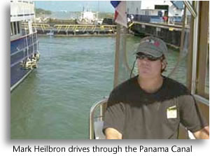
Mark Heilbron, an executive for a dental distributor serving the Hawaiian Islands, is a longtime sailor and fisherman, whose sideline has been to harvest tuna and other pelagic species for the local Asian market. Heilbron sought out Mirage because of the form stability of the Navigator hull, which he believed would serve him well in the fishing grounds off Hawaii. He specified some radical modifications, such as an aft sportfish-style flybridge and a large fish hold to indulge his passion.
As any trawler aficionado can tell you, trawler yachts derive from workboat designs. What Heilbron, working with Mirage, has accomplished in HoOkele was to bring this concept full circle, without sacrificing the yacht-quality features.
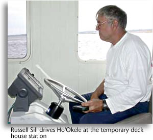 Russell Sill, 57, of Gainesville, Florida, is head rigger and engineer at Mirage, responsible for all system designs and installations in the companys trawler and sportfish lines. As such, Sill is well able to make any necessary repairs under way. Like Heilbron, he is an avid fisherman, having done so commercially for 24 years. He holds a captains license to carry passengers for hire and has made dozens of boat deliveries for Mirage during his 8-year tenure. Russell Sill, 57, of Gainesville, Florida, is head rigger and engineer at Mirage, responsible for all system designs and installations in the companys trawler and sportfish lines. As such, Sill is well able to make any necessary repairs under way. Like Heilbron, he is an avid fisherman, having done so commercially for 24 years. He holds a captains license to carry passengers for hire and has made dozens of boat deliveries for Mirage during his 8-year tenure.
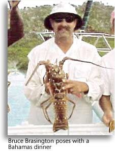
Captaining HoOkele is Bruce Brasington, 54, a former longtime Gainesville businessman who came to boating late in life. It wasnt until his 40s that he decided to adopt a seafaring lifestyle, but when he did, Brasington applied himself with the same discipline and zeal that had brought him success in business, success enough to retire early and become a full-time liveaboard. Brasington holds a captains license and has extensive East Coast and Bahamas cruising experience aboard his 36-foot PDQ catamaran. He has raced sailboats offshore and has extensive yacht delivery experience.
The strategy for reaching Hawaii is straightforward. The plan was to set a waypoint at the Islands and head to it. In heavy beam seas, the plan was to head off course and go down seas just enough to bring HoOkele into a comfort zone. In fact, such conditions were only expected near the continental United States. Once offshore, North Pacific pilot charts for March and April show consistently following conditions, including a .5-knot of favorable current.
HoOkele has shipped 1,030 gallons of fuel for the trip, which is calculated to take them to Honolulu with a reserve. Those calculations did not take into account the favorable currents
|
|
|
|
Updates Of HoOkeles Progress
|
|
|
|
|
|
|
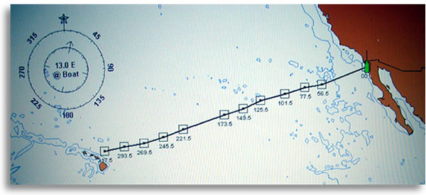
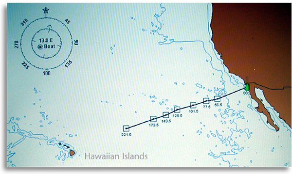
Hour 317.5
|
April 4, 2003; 1900 UTC, 1400 EST: Position 21o37 N 155o07W, 2135 nm from Ensenada, 144 nm to Hawaii WP. Average speed: 6.7 knots, 2- to 4-foot swells, 1- to 3-foot waves driven by 12- to 15-knot southeast winds.
|
|
|
|
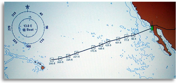
Hour 293.5
|
April 3, 2003; 1900 UTC, 1400 EST: Position 22o02 N 152o09 W, 1969 nm from Ensenada, 312 nm to NEW Hawaii WP. Average speed: 6.75 knots, 4- to 6-foot swells, 1- to 3-foot waves driven by 12 to 15 knot southeast winds. To avoid beam seas, course laid for Diamond Head. Crew longs for land. The fish arent bitting, and weve seen all the (goshdarn) movies, said skipper Bruce Brasington.
|
|
|
|
Hour 269.5
|
April 2, 2003; 1900 UTC, 1400 EST: Position 22o30 N 149o14 W, 1806 nm from Ensenada, 392 nm to Hawaii WP. Average speed: 6.7 knots, 8- to 10-foot swells, 3- to 4-foot waves driven by 20-knot east-southeast winds.
|
|
|
|
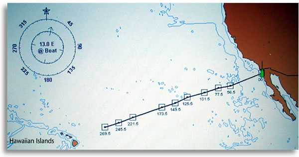
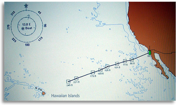
Hour 245.5
|
April 1, 2003; 1905 UTC, 1405 EST: Position 23o19 N 146o27 W, 1645 nm from Ensenada, 554 nm to Hawaii WP. Average speed: 6.7 knots, 6- to 8-foot seas, driven by 10-12 knot northeast winds, clear skies. Failed to land a 35-pound Ono for lack of a gaff.
|
|
|
|
Hour 221.5
|
March 31, 2003; 1915 UTC, 1415 EST: Position 24o12 N 143o31 W, 1476 nm from Ensenada, 725 nm to Hawaii WP. Average speed: 6.7 knots, 2- to 4-foot swells with 1- to 3-foot waves, driven by 10-12 knot east-southeast winds, rain and scattered clouds.
|
|
|
|
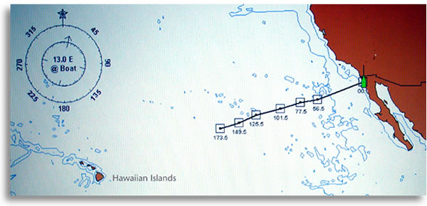
Hour 173.5 Halfway
|
March 29, 2003; 1910 UTC, 1410 EST: Position 25o58 N 137o29 W, 1137 nm from Ensenada, 1068 nm to Hawaii WP. Average speed: 6.6 knots, 2-to 4-foot swells with 1- to 2-foot waves, driven by east-northeast winds of 10 knots or less. Said Bruce Brasington: We caught a 20-pound Ahi (tuna). It took two people to pull it in. We had a slight injury, but we treated it. We need one purple heart at the dock when we get there.
|
|
|
|
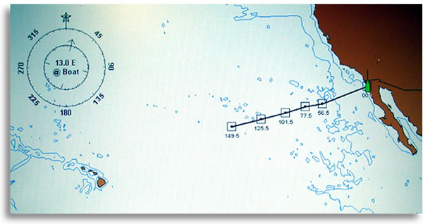
Hour 149.5
|
March 28, 2003; 1910 UTC, 1410 EST: Position 26o45 N 134o45 W, 984 nm from Ensenada, 1223 nm to Hawaii WP. Average speed: 6.6 knots, 6-8 foot swells with 2-4 foot waves, driven by 10-12 knot east-northeast winds, haze.The water temperature is 67.7o. Crew expects to catch fish when the temperature teaches 70o.
|
|
|
|
Hour 125.5
|
March 27, 2003; 1910 UTC, 1410 EST: Position 27o38 N 131o45 W, 817 nm from Ensenada, 1391 nm to Hawaii WP. Average speed: 6.5 knots, 6-8 foot swells with 2-3 foot waves, driven by 10-12 knot east-northeast winds, low clouds.
|
|
|
|
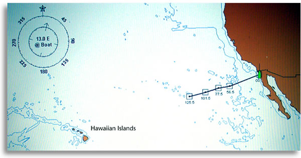
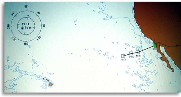
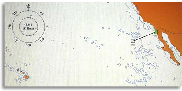
Hour 101.5
|
March 26, 2003; 1910 UTC, 1410 EST: Position 28o30 N 128o43 W, 650 nm from Ensenada, 1560 nm to Hawaii WP. Average speed 6.4 knots, 1-2foot seas from the northeast, calm winds.
|
|
|
|
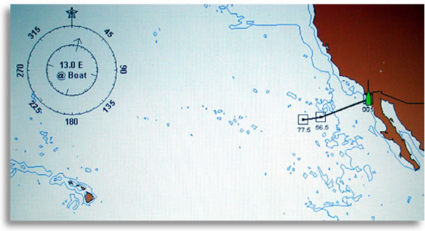
Hour 77.5
|
March 25, 2003; 1910 UTC, 1410 EST: Position 29o19 N 125o46 W, 492 nm from Ensenada, 1718 nm to Hawaii WP. Average speed 6.35 knots, 4-6 foot seas from the northeast, winds 10 knots or less from the northeast.
|
|
|
|
Hour 56.5
|
March 24, 2003; 2230 UTC, 1730 EST: Position 30o02 N 123o17 W, 359 nm from Ensenada, 1851 nm to Hawaii WP. Average speed 6.35 knots, 6 to 8-foot seas from the north, winds 12-20 knots from the north.
|
|
|
|
|
|
|